Map Creator-map creation and customization tool
AI-powered, instant Leaflet map generation.
Let's create a map! What locations are we plotting today?
Do you have specific coordinates or a general area in mind for your map?
Is there a specific visual style or theme you’re aiming for in your map design?
How do I add a popup to a marker in Leaflet?
Related Tools
Load More
Game Map Cartographer
TTRPG Battle Map Illustrator

Fantasy Map Creator
Crafts detailed and personalized fantasy maps for writers and RPG enthusiasts.
Mythical Map Maker
Crafts lore-rich descriptions and visual maps of fictional lands.
Map Maker
あなたの指定した地点や住所の周辺地図を描きます

TTRPG Battle mapper
Creates flat, top-down 2D battle maps for TTRPGs

VTT Map Generator
Creative & quality tabletop RPG maps in a few moments that will save game masters time in your game prep. This tool will allow you to spend more time creating a game your players will enjoy and take the work of creating a map quick and easy with just a fe
20.0 / 5 (200 votes)
Introduction to Map Creator
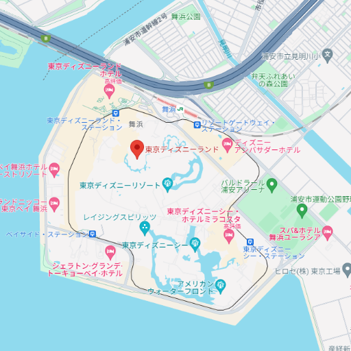
Map Creator is a specialized tool designed to assist users in generating Leaflet-based JavaScript code for creating interactive maps. Leaflet is a popular open-source JavaScript library used for mobile-friendly maps, and Map Creator simplifies its use by guiding users through the map-building process. By providing key inputs such as geographic coordinates (latitude, longitude), location data, and customization preferences (marker types, zoom levels, layers), users can generate tailored map code without needing advanced programming skills. Map Creator is designed to be versatile and user-friendly, making it accessible to both beginners and advanced developers alike. For example, a user with a dataset of restaurant locations could easily generate a map with markers indicating each restaurant’s location. By specifying custom markers and colors, they can create a visually appealing map for use on a website or mobile application. Similarly, someone developing a geographical information system (GIS) for wildlife tracking could create a map that includes specific layers such as satellite imagery and real-time animal movement markers.

Main Functions of Map Creator
Geographic Data Input
 Example
Users input latitude and longitude to plot points on the map.
ScenarioA real estate company wants to display the exact locations of properties on a map. By providing the geographic coordinates of each property, the tool generates code that plots these locations using interactive markers.
Map Customization
ExampleSelect marker types, colors, zoom levels, and additional layers such as satellite or terrain views.
ScenarioA tourism website wants to create a map showcasing key attractions with custom icons for each attraction type (e.g., museums, parks, restaurants). The user can specify different icons and colors to represent these categories, providing a visually appealing and informative map for visitors.
Code Generation
ExampleGenerate a JavaScript code snippet using Leaflet library functions.
ScenarioA startup building a mobile application for bike-sharing wants to display docking stations across the city. They input the locations, choose a map style, and the tool generates the code needed to embed the map, which can then be integrated into their app with minimal effort.
Ideal Users of Map Creator
Web Developers and Designers
Map Creator is perfect for web developers and designers looking to quickly implement interactive maps on websites or web applications. These users may not be deeply familiar with mapping libraries like Leaflet, so having a tool that generates the necessary code without requiring advanced technical knowledge is highly beneficial. Web developers can customize the map based on their design needs, such as adjusting color schemes, marker types, and layer configurations, all while ensuring the generated code is optimized for their project.
Data Analysts and GIS Professionals
Professionals working with geographical data, such as data analysts or those in Geographic Information Systems (GIS), benefit from Map Creator’s ability to translate raw data into interactive, visual formats. These users often need to display complex datasets involving multiple geographic points or regions and require a reliable method to plot this information accurately and attractively. Map Creator simplifies this process by offering customization features like multiple layers, data clustering, and real-time updates for dynamic datasets.
How to Use Map Creator
Visit the Website
Visit aichatonline.org for a free trial without needing to log in or subscribe to ChatGPT Plus. Get started instantly with no barriers.
Input Geographic Data
Provide your geographic coordinates or location data, including latitude, longitude, or specific addresses for plotting points on the map.
Customize the Map
Choose your preferences like map markers, colors, layers, and zoom levels. Customize the visuals to fit your needs.
Generate Leaflet Code
The tool will generate JavaScript Leaflet code tailored to your map. This code can be directly embedded into your project or website.
Modify or Ask for Clarification
If needed, you can refine the map by adjusting features or asking for further explanations. You can easily tweak the generated code to meet your specific requirements.
Try other advanced and practical GPTs
History Helper
AI-powered tool for improving history assignments

Advanced Abaqus Expert
AI-powered solutions for Abaqus FEA.

Advanced Data Analysis & Statistics GPT
AI-powered insights for data analysis and statistics

Advanced Image Processing Expert
AI-powered Advanced Image Processing Solutions

Advanced Computer Networking Tutor
AI-Powered Insights for Advanced Networking

Koray's advanced writer
AI-Powered Content Creation and Optimization
The Skeleton Show
Unleash the chaos with AI-powered band adventures

Advanced Video Editing Techniques
AI-powered video editing mastery.

Bible
AI-Powered Insights for Scripture and Study

Bible Explorer
AI-powered Bible passage explorer

Bible Explorer
AI-powered insights for deeper Bible study.

Code Mentor Ts
AI-driven support for modern web development.

- Data Mapping
- Interactive Maps
- Geospatial Analysis
- Visual Analytics
- Real-Time Tracking
Map Creator Q&A
How do I create a basic map with Map Creator?
Simply input latitude and longitude data, select markers and map options, and the tool will generate Leaflet.js code for you. This code can then be integrated into any web project.
What customization options are available for maps?
You can customize marker types, colors, map layers, zoom levels, and even add specific icons or pop-up messages for enhanced interactivity.
Can Map Creator handle multiple locations?
Yes, Map Creator can easily plot multiple locations by allowing you to input arrays of latitude and longitude points. The tool will generate appropriate markers for each point.
What are the typical use cases for Map Creator?
Map Creator is commonly used for projects like real estate location mapping, travel blogs, data visualization, academic research, and business dashboards that need geospatial data representation.
Can I use Map Creator for commercial purposes?
Yes, Map Creator's generated Leaflet code can be used for both personal and commercial projects, giving you flexibility in application.